In 1891, Elizabeth Regan (blog of 19 August ) and James Waddington are living with their three children in Pickle Herring Street, Bermondsey which has now disappeared but was right next to Tower Bridge.
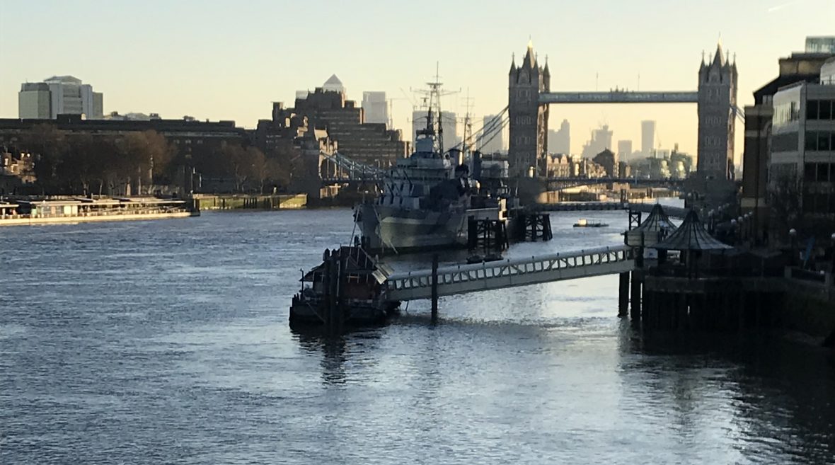
Many people know the current walkway beside the Thames, between London Bridge and Tower Bridge. About halfway along is the museum ship HMS Belfast. In the 1980s, before the walkway was created, this part of the riverfront was called Symonds Wharf. There was also a flight of river-stairs called Pickle Herring Stairs along with a causeway very close to this spot.
In the days when large cargo ships moored alongside this piece of riverfront, there was also a street running behind the warehouses that lined the river which extended east from these stairs and eventually passed under the approach road to Tower Bridge. Much of that land is now a park called Potter’s Fields. Now used by tourists to stand and admire views of Tower Bridge and the Tower of London and the site of The Greater London Authority Headquarters, City Hall.
The old thoroughfare was called Pickle Herring Street.
Potters Fields is so called because of the Dutch potters who came to work here having fled religious persecution in Holland. It was the site of the earliest Delftware kilns in England, established around 1618 and the area became famous for producing a particular variety of Delftware called ‘Pickle Herring pottery’. The theory that the Dutch fondness for pickled herrings gave the street and the nearby river stairs their name is sometimes proposed but likely to be unfounded. The precise origin is not known, but is much older.
I find the street fascinating. If for no other reason than it was right next to Tower Bridge where thousands and thousands of tourists now tread with no-one knowing (or probably caring) that once not so long ago people lived there packed into cramped and horrid conditions carving out a meagre living in the Docks.
I have found out quite a lot about the street though. A publication called Old and New London, published in 1878 describes the area as follows,
“From about the middle of Tooley Street, on the north side, to St. Saviour’s Dock, the whole line of street – called in one part Pickle Herring Street, and in another Shad Thames – exhibits an uninterrupted series of wharves, warehouses, mills and factories, on both sides of the narrow and crowded roadway. The buildings on the northern side are contiguous to the river, and in the gateways and openings in these we witness the busy scenes and the mazes of the shipping which pertain to such a spot. “
The following early 19th century map extract shows the area prior to the construction of Tower Bridge. Note Horsleydown Old Stairs. This is where Tower Bridge would be built later in the 19th century.

There was also a Pickle Herring Stairs roughly where St. Olave’s Wharf is shown in the 1940 map shown below. It is interesting to note that Pickle Herring street was directly opposite Traitor’s Gate of the Tower of London. I struggle to imagine how much money a person would need to live in such a prime location today.

The following two photographs from 1947 and 2015 respectively show how the area has changed in so little a time really. The 1947 photo immediately below is looking East towards Shad Thames now a site for high end restaurants and even higher end flats and apartments,

and this photograph looking west shows what is now the site of the seat of London Government, City Hall built on Potter’s Field.

When the south bank of the Thames was redeveloped in the 1980s, a new river-wall, from London Bridge to Tower Bridge was built and anything pre-1980 was cleared away. All reference to Pickle Herring Street was lost.
There is mention of Picked Herring Wharf in the novelist and historian Walter Besant’s book East London, 1901 together with this illustration which shows the bridges in the Wharf which can also be seen on the 1947 photograph above:

Additionally, the artist and illustrator Gustav Doré visited the area in about 1872 and produced this illustration of the Wharf:

Pickled herrings are an age-old method of preserving a very well-known fish. They are also known as rollmops. Pickled herring fillets, usually served these days rolled up with onions or gherkins inside and bought in a jar or other container of vinegar. They are well-known and eaten in Britain as well as being even more popular in Europe and particularly Scandinavia. The idea of a pickled herring in London is known to go back to the days of the Domesday Book in 1086 where Herrings and Southwark are mentioned together in a reference for the ‘Guildable Manor of Southwark’. This manor extended from the southern end of London Bridge, along the riverside, almost as far as Hay’s Wharf Dock nearer to London Bridge.
This mention is related to lands held by Odo the Bishop of Bayeux. Along with several pieces of land in England, there is a reference to ‘Oxted and Walkingstead, in Tandridge Hundred, land of Count Eustace’. Under this entry, it says ‘The Count holds Walkingstead himself … To this manor belong 15 dwellings in Southwark and in London, at 6s, and 2000 herrings’. The mention of the ‘six shillings’ and also the herrings probably indicates that taxes had been levied and were payable partly in money and the rest in herrings. Because fresh fish would not have kept, it is likely that the Herrings would have been pickled before being handed over in payment.
Pickle Herring Stairs could be the place where the herrings were landed, pickled and used as a kind of currency.
Who knows? But it’s an intriguing story.

Excellent blog Linda.
I also had relatives living in Pickle Herring Street and other streets in the area.
In 1891 my grt x 3 grandmother (Bridget Doherty) was living at 19-24, 3 Block, Barnham Street Buildings, Pickle Herring Street, Horsleydown with her son’s family.
The Charles Booth survey has some interesting information about the area and a map showing Pickle Herring street: https://booth.lse.ac.uk/map/17/-0.0813/51.5049/100/0
Policeman’s notebook, pages 65 – 89:
https://booth.lse.ac.uk/notebooks/b364#?cv=47&c=0&m=0&s=0&z=-423.2546%2C0%2C3216.509%2C1481
LikeLiked by 1 person
Hi Phil, Thank you for your comments (and glad you like my blog – early days yet – it was my Lockdown#1 project and it took me some time to get the confidence to publish it!) I do find the Booth maps fascinating. Such an insight into our ancestors’ lives. I did though, miss the notebooks so thank you for pointing them out to me. Someone wrote to me after reading this story and said a relative of hers had worked on the SER railways extension. And Sgt Avery’s notebook is just super fascinating so thank you again. Gosh that’s fascinating, that you had relatives there the same time as me. I’d like to think they knew one another! Anyway, thanks again for getting in touch and for “following” my blog too. It’s always nice to know someone’s out there so to speak. Linda.
LikeLiked by 1 person
Hello Linda, Lovely to find your blog. My family were wharfingers at Pickle Herring Lower Wharf in the 1800’a. If you’d like to get in touch we can exchange more information. Thank you.
LikeLiked by 1 person
Hi Lynda. thank you for your comment. I have been doing more research than blogging for a while so sorry I didn’t acknowledge your comment sooner. I’d love to know more about your relatives. I had to look up the term Wharfinger but as usual Google has been my friend and I now understand. If you get a moment, it would be good to know some more about your family. Again, sorry for my delayed reply. Best wishes, Linda.
LikeLiked by 1 person
My ancestor John James Speer worked as a Wharfinger’s clerk in the St Olave area. I wondered whether you knew of him please. I enjoy your blog very much
LikeLike
I’m afraid I don’t (know a James Speer) but I’ll look out for him. I am so glad you enjoy my blog. I haven’t done a new one for such a long time. But I’m inspired now to start again. Thank you once more for reading my efforts!
LikeLike
hi, I’ve just found my husband’s relatives living at 5 Barnham street buildings. No 2 Block Horslydown in 1891 c. Strangely his occupation was a “lawn tennis court ( marker)” not too sure what the last word says.
LikeLike